

 |
When established in 1777, Washington County lay mostly south of the Watauga River and Jonesborough was established as its county seat in 1779. This 1800 map shows the few towns that existed in the region.1 |
 |
Washington County in 1814, after several other counties had been established.2 |
 |
The election districts of Washington County were laid out in a map c.1815.
3 The Tennessee GenWeb site for Washington County has a description of the districts created by a State Assembly act in 1835. |
 |
In the Washington County tax lists recorded by the County Clerk, there is another map of the civil districts included with the 1843 tax listing - slightly different from the earlier map but clearly copied from it.4 |
 |
Current topographical map of Washington County - note the large number of small creeks and streams. |
 |
This is an approximate outline of the Brush Creek election district superposed on a current terrain map. |
In 1776, Washington District was created as part of North Carolina, comprising what eventually became the state of Tennessee. In 1777 Washington County, Tennessee was created and in 1779 Sullivan County was created from part of Washington. By 1796 Washington County had attained approximately its current size and shape with Unicoi County finally being created in 1875 from part of Washington and Carter counties.

The Great Valley Road appeared on a 1755 map of Virginia drawn by Thomas Fry and Peter
Jefferson (father of Thomas Jefferson).5 The section that passed through Augusta County is
shown along with the Beverley Manor and Borden tracts where the Young and Douglass families lived in the
1740s. The modern towns of Harrisonburg, Staunton and Lexington are indicated but did not exist in 1755.
See also the Borden Tract map in the Maps section of this page.

A current terrain map of the Shenandoah Valley in southwest Virginia and northeast Tennessee
is overlaid with the original migration paths, showing how the families of Augusta County, Virginia, moved
to the Watauga Settlement area of the then western region of North Carolina. See the Watauga Settlement
map below.

The Holston, Nolichucky and Watauga Rivers defined the general area of the Watauga
Settlement. The earliest white settlers along the Watauga River created the Watauga Association in 1772
to provide government for the area. They had bargained with the Cherokee to lease land along the river
after a survey showed that many of the settlers lived in part of North Carolina's western claim, which
had been set aside for the Cherokee. A well-written history of the Association can be found at the website
of the North Carolina History Project,6 which is a special project of the John Locke Foundation.
The Young family came to Tennessee (then North Carolina) probably in the early 1770s since Robert Young's oldest son, James, was born in North Carolina in 1774-5. This is also the time that Jonathan Douglass (father of Phebe Douglass, wife of Robert Young) came to the same area - see the Watauga Settlement map in the sidebar that shows Carter's Valley near the Holston River where Jonathan settled. They had an “easy” route to take, the well-traveled Great Wagon Road (also called the Great Valley Road) that extended from Winchester southward in the Shenandoah Valley to Big Lick (now Roanoke). From there, they would have continued southwest on the Valley Pike to an area between present-day Bristol and Kingsport, then part of the Watauga Settlement (see the sidebar).
The deeds of Washington County for the Young family show dozens of transactions over a century's time. The family settled in the Brush Creek district (see above maps) and they owned considerable land in what became Johnson City. Robert Young, soldier of the Revolutionary War, was buried on what eventually became the grounds of the National Guard Armory, 2109 West Market Street, Johnson City. The cemetery is located to the rear of the old armory building, which is now the East Tennessee State University Innovation Laboratory.
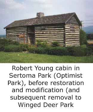
Robert Young's cabin still exists in Washington County, though it's been relocated from the original family land to a park and it has been updated and modernized for offices.
The Johnson City web site, Parks and Recreation office, used to have a good photo of Robert Young's original cabin (but no longer does so click here for image), which originally stood on his property next to Brush Creek: "Robert Young Cabin one of Johnson City's oldest dwellings. Built in the early 1770's, the Robert Young Cabin sat on family property located near Brush Creek. The U.S. Government purchased a portion of the Young's family property for the National Soldiers Home, which necessitated the cabin's first move. Relocated to Optimist Park, then known as Sertoma Park, the cabin was restored in 1938 by the John Sevier Chapter of the Daughters of the American Revolution. Following the cabin's second move in 1996 to its current home at Winged Deer Park, it was substantially renovated and repaired. The log structure of the cabin has endured well over 200 years."7 Winged Deer Park, 242 Carroll Creek Rd, Johnson City, TN 37601-2904. Located north of Johnson City, near where Bristol Highway crosses the Watauga River.
Robert Young's wife, Phebe Douglass, had a sister, Naomi, who married Valentine Sevier, brother to John Sevier, a major figure in the history of Tennessee. He fought in the battle of King's Mountain after his move to western North Carolina and the Watauga Settlements in 1773. The Young, Douglass and Sevier families moved together through the Shenandoah Valley from the Augusta County, Virginia, region to the Watauga River area, apparently in 1772-3. A brief history of John Sevier is presented in another website of the North Carolina History Project.8 In addition, the Tennessee GenWeb site has a good short history of John Sevier.
There are several cemeteries for members of the Young family, which are listed under the Young surname on the Tennessee GenWeb site for Washington County.
1. "Carte de la Partie Meridionale des
Etats-Unis," published c.1800; lower left corner "Grave par P.F. Tardieu,
Place de l'Estrapade No 18"; upper left corner "Pl. IX a la Fin du Tom. II";
covers North and South Carolina and parts of Virginia, Kentucky, Tennessee
and Georgia; digital image, Tennessee Virtual Archive (
https://teva.contentdm.oclc.org/digital/
collection/p15138coll23/id/74/rec/1 : accessed 2 Dedc 2022).
2. Mathew Carey, Carey's General Atlas, Improved And Enlarged; Being A
Collection Of Maps Of The World And Quarters, Their Principal Empires,
Kingdoms, &c. ... Philadelphia (Philadelphia: Mathew Carey, 1814);
digital image, David Rumsey Map Collection (
https://www.davidrumsey.com : accessed 14 May 2009).
3. [Map] ca. 1815, Division of Washington County, Tennessee into election districts : a machine readable
transcription of an image. Availability: This work is the property of the Special Collections Library,
University of Tennessee, Knoxville, TN. It may be used freely by individuals for research, teaching, and
personal use as long as this statement of availability is included in the text. This document is a
hand-drawn map circa 1815. It divides Washington County, Tennessee into seventeen election
districts. Collection: Fink & Dulaney Papers.
4. "Washington County Tennessee Tax Books 1814-1850," unpaginated entries arranged
chronologically, civil district map included at end of 1843 entries; FHL microfilm 825,546.
5. Map of the Inhabited part of Virginia, containing the whole province of Maryland with Part of
Pensilvania, New Jersey and North Carolina (London: Thomas Jeffreys, 1755); digital image, Library
of Congress American Memory Collection (
https://www.loc.gov/item/74693166/ : accessed 14 May 2009). Drawn by Thomas Fry and Peter
Jefferson (Thomas Jefferson's father).
6. Michael Toomey, North Carolina History Project : Watauga Association (
https://www.northcarolinahistory.org/
encyclopedia/98/entry : accessed 5 May 2009).
7. City of Johnson City, "City of Johnson City, TN - Parks and Recreation - Winged Deer
Park," (
https://www.johnsoncitytn.org/residents/
parks_and_facilities/residents/
winged_deer_park.php : accessed 15 May 2009).
8. Michael Toomey, North Carolina History Project : John Sevier (1745-1815)
https://www.northcarolinahistory.org/
encyclopedia/127/entry : accessed 5 May 2009).